|
Current Inventory: · Books · Maps · Ephemera |
|
Services: · Antiquity & Artifact
Appraisal · About |
Remote Sensing Services
|
I am very experienced with hydrographic survey
using sidescan sonar and remote operated
vehicles. I am familiar with most
remote sensing tools and have worked with several mapping and survey
products. I am also an experienced ROV
operator and repair technician. In the
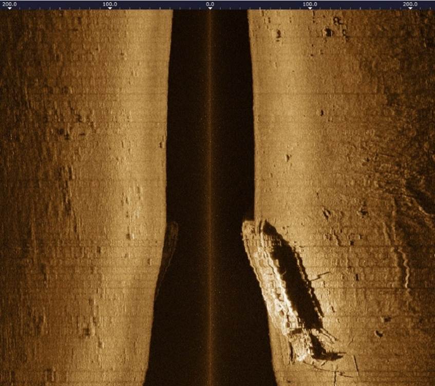
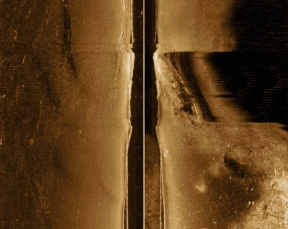
past four years, I have located five historically important lost ships, four
of which are now on the National Register of Historic Places. These include the following: · Paddlewheel steamer L.W. Crane I located all of these using sidescan sonar operated from my boats in a variety of environments from shallow river sites to deep sites in Lake Michigan. I also teach courses on sidescan sonar operation and interpretation and ROV piloting for the Wisconsin Underwater Archeology Association. I own two sidescan sonars and two ROVs, which I use in the field, and I am the US technical support person for DeepVision sidescan sonars. My services in this area are as follows: 1. Sidescan Sonar Training – I offer onsite courses in the operation, interpretation and troubleshooting of sidescan sonars. I have worked with nearly every brand of sidescan sonar over the years an am familiar with nearly every software package. I currently offer a sidescan sonar course for the Wisconsin Underwater Archeology Association. I am happy to offer training to organizations or individuals. 2. Sidescan Sonar Survey – I will travel regionally to help locate objects in water under 400 ft. deep using my equipment. I can also provide hydrographic survey services that involve mapping large areas of bottomland in high detail. 3. ROV Training – I offer courses in the operation, troubleshooting and rescue of Remote Operated Vehicles using Chasing ROVs. I currently offer an ROV course for the Wisconsin Underwater Archeology Association. I am happy to provide training to organizations or individuals. 4. ROV Survey – I am happy to travel regionally with my ROVs to survey objects in under 200 ft. of water. My ROV does not include an on-board sonar or location system. My services in this regard are basic and priced accordingly. See examples of hydrographic survey
projects I performed with sidescan sonar: · Full bottom mapping of the Kinnickinnic, Menomonee and Milwaukee Rivers in high resolution · Full bottom mapping of Eagle Harbor at Ephraim, Wisconsin in high resolution · Mapping of historic fish weirs at Aztalan State Park · Identification of over thirty shipwrecks in the Keweenaw Waterway Watch one of my sidescan
sonar courses at: https://youtu.be/BbS2n_t0rUQ To discuss your remote sensing needs, email me at baillod@shipwreck.info. For large projects, I may ask that we have a contractual agreement. |
|
Baillod Maritime Antiquities Venmo / Paypal: baillod@gmail.com |